Glastonbury Pilgrimage Routes
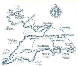
There are several long-distance walking trails passing close or through Glastonbury. The most famous one is the Michael/Mary line from Land's End in Cornwall to Lowestoft in East Anglia, over the St. Michaels Leyline. There is the Samaritans Way, the Monarch Way and the Leyland Trail all passing close to Glastonbury.
There is also the West Mendip Way, leading you over the Mendips in 2/3 days from Weston-Super Mare to Wells near Glastonbury. From the ridge of the Mendips starting from Weston, there are superb views over the Axe Valley, dominated by Glastonbury Tor in the distance.
Once you are here though, there are lots of different lanes, byways and paths around Glastonbury itself that would help you to feel you were connecting with the sacred energies of place. However your journey to Glastonbury is undertaken, may you find what fills your heart, feeds your mind and inspires your imagination.
The Wells to Glastonbury Pilgrimage

11.5 miles Easy Grade Walking with three moderate ascents.Two Tips for visiting Glastonbury…One - There is no better way to arrive then by climbing over the lonely and dramatic Glastonbury Tor and pausing to drink in the views, before descending into the mystical mayhem of the town that clusters at the foot of the Tor.
Two…. And if you are going to arrive via the Tor, then the best way to do it is by using your own two feet, following your own personal pilgrimage from Wells Cathedral to the holy ruins of Glastonbury Abbey. Walking in from Wells, you avoid the day-trippers by sneaking up to the Tor from the East, appropriately hobbit-like on a “back door” route through a swathe of hidden, rural Somerset.
Read more by visiting Encounter Walking...
The Mary Michael Pilgrims Way

A developing route, aiming to establish a walking pilgrimage route across England, from Cornwall to Norfolk. This route passes through diverse landscapes connecting significant Christian and pre-Christian sites, creating a spiritual and cultural journey which offers opportunity for reflection and inspiration.
The pilot project between Brentor and Glastonbury has now been extended. The route now stretches over 350 miles, from west Cornwall to Avebury, with guidebooks available describing the whole way.
Find out more on the Mary Michael Pilgrims Way website
The pilot project between Brentor and Glastonbury has now been extended. The route now stretches over 350 miles, from west Cornwall to Avebury, with guidebooks available describing the whole way.
Find out more on the Mary Michael Pilgrims Way website
The Samaritans Way

A wonderful way marked 100 mile/160kms walk through Somerset linking the Cotswolds, the Mendips, the Polden Hills, the Quantocks, the Brendons, Exmoor National Park and the North Devon Coast. It starts at Clifton Suspension Bridge on the spectacular Avon Gorge, and continues across the Chew Valley with its peaceful lakes, over the Mendip Hills to Cheddar Gorge, along the Somerset Levels to historic Glastonbury and on to the Quantock Hills with a scenic ridge walk passing through the villages around the Brendon Hills. The route then crosses Exmoor to Doone Valley and Badgworthy Water, follows the East Lyn River and climbs Myrtleberry Cleaves to Lynton.
Visit the Bristol Ramblers website to find out more...
Visit the Bristol Ramblers website to find out more...
The Celtic WayRanging almost 800 miles from North Wales to the tip of Cornwall, this pilgrimage reflects this long history, allowing you to encounter more than 100 pre-historic sites through South Wales and the South West. It is based partly on the Lands End Way, with alternative routes over Exmoor or across Wessex also on offer. If you have a few months to spare, and wish to do honour to the ancient stones of Pembrokeshire, Stonehenge, Glastonbury, Exmoor and St Michael’s Mount.
Read more by visiting The British Pilgrimage Trust... |
The Monarch's Way

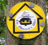
A 615-mile (990 km)long-distance footpath in England that approximates the escape route taken by King Charles II in 1651 after being defeated in the Battle of Worcester. It runs from Worcester via Bristol and Yeovil to Brighton. All of the footpath is waymarked. The waymark is yellow and shows a picture of the ship Surprise above the Prince of Wales three-point feathered crown which is superimposed on a Royal Oak tree (which is at Boscobel House) in black.
The closest it comes to Glastonbury is Wells.
Find out more...
The closest it comes to Glastonbury is Wells.
Find out more...
Walking in the Avalon Marshes

The Avalon Marshes were a vital resource for local communities, including grazing, turf cutting, and reeds for thatching. As a result many footpaths, droves and lanes link these communities to the marshes. These are ideal for walking, and the great folk out at the Avalon Marshes have developed a series of Circular Heritage Walking Routes which help you fully explore the area.
Read more on their website...
Read more on their website...
Glastonbury walks to download for free
Several walks can be found on John Harris' Walking in England website. Click on the image to find them.


